

SERVICES
FIRE
FLOOD
ENERGY
LAW ENFORCEMENT
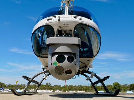
Utilising the very latest multi-sensor payload on aerial platforms, Aerial Imaging Group can adapt to a variety of assignments to capture, report & communicate detail that is hidden to the human eye. Efficiency is key when in an aerial environment. Our ability to capture IR, High-resolution photographs, HD video, Corona detection & GPS mapping simultaneously delivers essential intelligence in real-time. Data is captured on board the SIG platform with the option to transmit to command centres, field operations & remote monitoring sites in real-time utilising cellular-bonded technology together with satellite data connectivity.
OUR WORK
Our aerial intelligence services across Australia offer cutting-edge solutions with advanced multi-sensor cameras and fast response times. Utilizing high-resolution imaging, thermal, and corona sensing technology, we provide precise and efficient monitoring for industries including agriculture, security, firefighting, and infrastructure. Whether you need real-time data, detailed analysis, or aerial inspection, our state-of-the-art technology ensures superior coverage and accuracy for all your intelligence needs. Aerial Imaging Group has a proven record for reliable, advanced aerial intelligence with rapid response across Australia.


ABOUT US
Aerial Imaging Group was formed by a collection of aviation focused professionals whose experience with aerial-based camera platforms is unrivalled in Australasia.
Using the latest in intelligence gathering camera platforms, we continue to push the boundaries with what can be seen & achieved from the air. Aerial Imaging Group brings a wealth of International experience, our directors have a long history of high pressure events & projects in different parts of the world.
Through our collective experience in aviation, we understand the importance of safety; the only way to be efficient & effective on a mission is to be first & foremost safe. Operating a variety of gyro-stabilised camera systems throughout Australia, we are also at the leading edge of cellular-bonded technology allowing field operational crew to see intelligence in real-time.


Contact
18 Compass Rd,
Jandakot WA 6164.
Phone West Coast
+61 (0) 412 912 574
159 Racecourse Rd,
Flemington VIC 3031
Phone East Coast
+61 (0) 416 061 713


